There is an anchorage on Bressay, the island opposite Lerwick which protects it from the east, which is almost landlocked by an islet in the narrow entrance to the bay. Aith voe is its name and it lies on the north east side of the island. Why this place in particular, well apart from being a nice sheltered spot for the night, it also has, close by, a WWI gun on the top of a hill. Score hill overlooks the north-eastern approaches to the safe anchorage of Lerwick, but quite how they managed to get this gun up here I don't know.
The climb to the top, according to the OS map, was 65 metres. The only thing is I forgot to take the map with me and I climbed the wrong hill first off, having to traverse a geo between the two hills, bugger. You can see the gun centre top of the mound.
And here it is, breech missing, but still on its mount and surrounded by a low concrete parapet.
I measured the bore, just under six inches. With the rust it may have been a six inch gun I don't know. It appeared to have two large (recoil) springs mounted underneath.
These two alcoves were either side of the access from the path to the magazine.
The entrance to the magazine, a winding path and lower than the gun platform.
On the way down I stopped off at a quarry that was used, amongst other things, to supply the flag stones for the streets of Lerwick.
Tutak, anchored in the distance over the spoil heaps.
Maybe this ewe is pondering the choice between the abattoir or an earlier demise at her own hoof.
The last section was a bit boggy being the run off from the lake above. In the more sedentary streams the dreaded midges were congregating so I made a hasty retreat to the safety of the boat.
It's nice to visit familiar haunts. No stress as you know what to do and where to go. Always finding new places actually means doing a lot of work especially if the pilot books don't list where you want to go. 'Anchor in the east of the bay' the book might say. But I want to anchor in the west to get out of this large wind. Why can't I anchor in the west, well get in the dinghy with the portable gps and lead-line and find out. This means dropping the hook in the east where it's poppley and getting wet whilst making sure that there are no rocks in the way. I digress, Lerwick is a wonderful place and after stuffing myself with a most wonderful Chinese take out, I set about finding someone who could fix my alternator. Maybe I wasn't clear but everyone kept telling me to go to the marine engineering places. I knew those from the last trip so I went to Thule Craft and explained. She got on the phone and called Campbell, who said Shaun was the man, up by the carpet shed near the incinerator. Out comes the laptop and a map of Lerwick comes up with Shaun of Autolec, off comes the alternator and out comes the bike and off we set to see Shaun. Shaun has a large machine that can do magic with alternators, dynamos, starters, distributor caps, leads, everything you would need to do to machines of the last century and he knew how to use it. Best of all he could fix it with stuff he had in stock (also from the last century probably). He also checked my spare alternator too and diagnosed the problem with that. Now I have loads of electricity to keep the fridge running and cold for the beer.
Walther came to visit. You can tell it is a German ship, the crest is a give-away, and somehow the courtesy flag is the Union Flag and not the Red Ensign, unless the Treaty of Versailles has made other arrangements?
I left Lerwick at the start of the Boat Clubs annual regatta, sunshine and not much in the way of wind.
Some parts of the waterfront are naturally quite commercial but this is the scene as you exit to the south.
As it was a calmish day I was keen to see if I could find the "Orkneyman's Cave", full of mineral colours and stalactites and accessible by dinghy. There are supposed to be mooring rings in the cliff face as it is steep too around there. I couldn't see them and it wasn't as calm as I thought it was going to be anyway! I think I identified the cave you can just see the start of the colouring inside. It opens up and is rather large once you get in. A bit further along are the "giant's legs" or something.
Just round the headland with its reef, is Noss Head, home of gannet city.
There is an even bigger cave here, one into which even Tutak might fit. Being on the lee side it was also a lot more comfortable. I managed to get quite close but bottled it when I felt "suck" when one is drawn, against ones will, inexorably into a black hole, nah Blad.
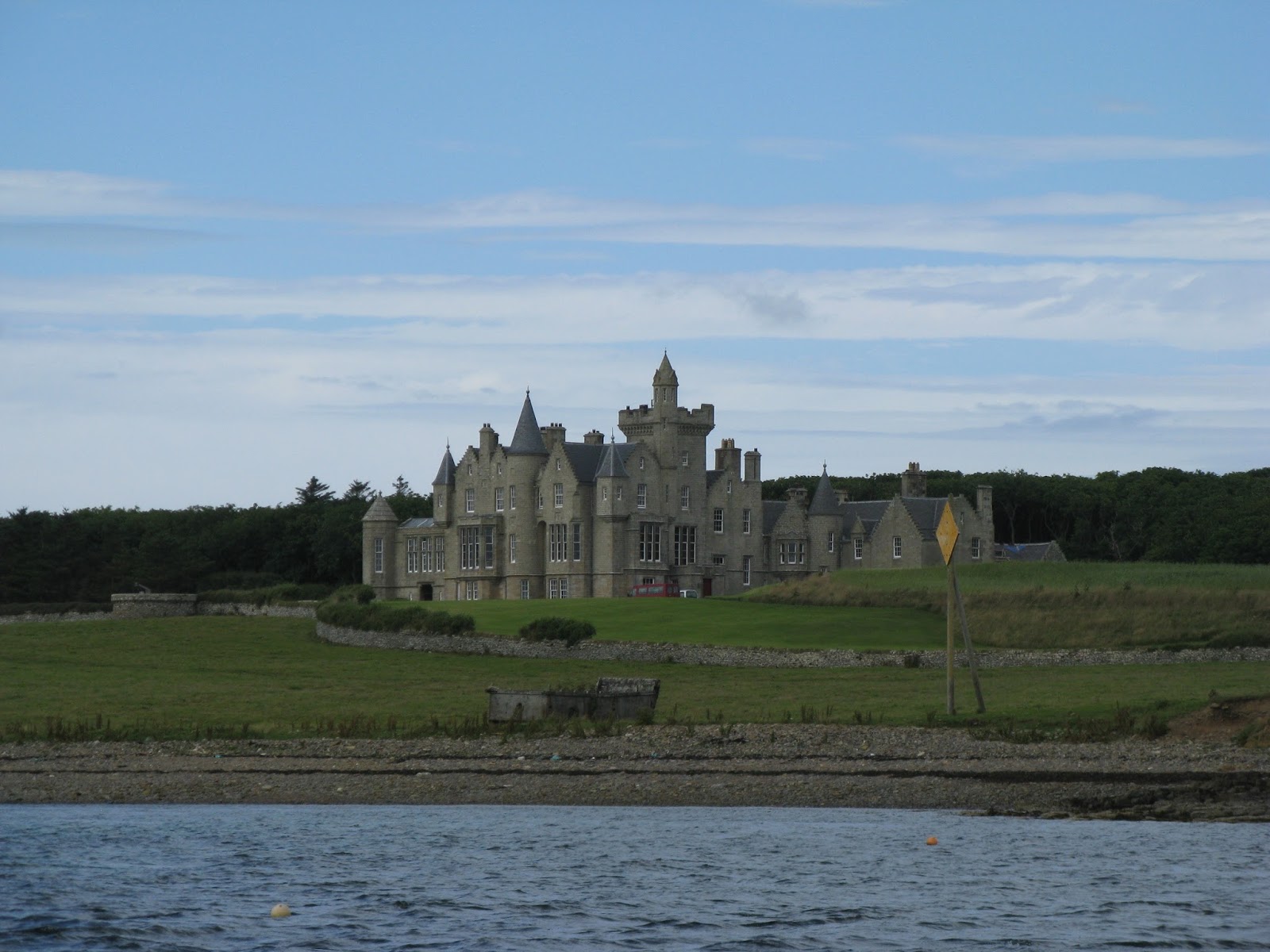
It was coming up for springs again, exciting times in the islands where the tidal streams rip between the islands and one can easily be doing double figures. Leaving Balfour Castle behind Samantha took us around the west side of Shapinsay.
And north for the crossing of the Westray Firth. This is open to the North Atlantic and its swell. The opposing brisk tide makes for, and I quote, "Violent turbulance on the flood..." There were poppley bits here and there round the corners of the islands and where the currents meet but in the distance great heaps of darkness topped with shimmering white prompted me to have another check at exactly where I was going. All plain sail was up and we were having a lovely sail. The swell was 3 metres but longish so not a problem, it was the big standing waves I was a bit concerned with as we were getting closer. In theory our destination should have avoided the worst of the rost but I was not so sure. We were cracking along heading east but travelling north and I couldn't see the gap between the islands but then it opened up and I had to take over from Samantha as the eddies were a bit strong and Tutak wanted to dance. Then it was all over and we were in the quiet and sheltered waters of the Sound of Farray, still force 5 but no waves, wicked.
At the other end of the sound we found ourselves as hard on the wind as Tutak goes without resorting to help from the propeller. After a few tacks we had had enough and, with the wind over the deck now 26 knots, the engine was fired up and we headed straight into it. Tutak likes this and the bluff bow smashes each wave into foaming spray, chucking it all over the poor fellow trying to tame the flailing sails into some order. The heater worked hard too, drying me and the wet gear, my umbrella was useless in that sort of wind. I think Dyson ought to invent a proper umbrella!
Shelter came from the island of Westray directly ahead and soon the harbour of Peirowall greeted us. A Dutch boat was leaving in the dusk to take their fair wind somewhere. I fetched up on another of the buoys kindly put their for visiting yachts. Perfect shelter even with the wind trying its best to upset things. I left the mizzen up to keep us into the wind as there is no tidal stream to affect things here.
Keen to take the wind east to Fairisle I was off again the next morning for the forty odd miles. I went straight past last time as the sailing was good, I don't get that many good sails on Tutak and I like to make the most of it. This time I was tempted as the wind was failing, the south harbour was going to be my destination. There is an anchorage there but it is littered with rocks on the entrance so you do need to be careful. However the swell was from the south, how that happened, as the strong winds had been from the west, I don't know. The north haven was therefore the obvious choice.
The entrance is ok and lit although I wouldn't want to try it for the first time in the dark. There was space for us to lie against the quay. The island provides big fenders for you to loan as, although sheltered, surge makes its presence felt.
The boat behind was the one I saw leaving Periowall as I was arriving. Paula and Jan, Jan has sailed twice round the world, three hundred days at sea once. Made of stern stuff the Dutch.
Did a bit of exploring on the new folding bike, went to the shop, bought card, wrote card, missed the mail boat so my daughter's card will be late, bugger.
Not so sure about bikes with small wheels, felt as though I had to hold onto the handlebars all the time. Ah well, time for a paddle and out came the kayak and off I went to explore the stacks, arches and caves. Got bombed by some birds that seems bothered at my nearness. Went into one cave backwards as it was a bit narrow. All of a sudden I am eating sand as a bigger wave than normal chucks me right into the beach at the back of the cave. It was a bit awkward to extricate myself and the water coming in was more powerful than me but I am here so I managed it in the end.
The mail boat arrived back with stores, a car, the waste skips, gas bottles, drums, passengers and loaded wool. I never realised they had lorries and cars on Fairisle, somehow I imagined a basic living, not so perhaps.
Peace returns to the harbour after a mad half hour which happens twice a week weather dependant of course.
After a fine sunny time in Fairisle we headed north one evening for the twenty mile sail through the "Hole", a stretch of water between Fairisle and Sunburgh Head known for its particular nastiness. It wasn't too bad that evening and we dropped anchor to the setting sun in Grutness Voe, south Shetlands.
The morning brought us a flat calm.
So we had a slow motor past the cliffs and rocks, through the Mousa sound and its particularly well preserved broch.
And on into Lerwick, with the best Chinese in Christendom.
Peterhead is a wonderful place, particularly when you arrive on carnival week. Triathlons, sandcastle competitions, raft races, the fair.
At first I thought that the Radio One Road Show was in town but there was some very loud music accompanying the fervent sandcastle building. The fog cleared for the day before returning in the evening. It was clear the following day so I set forth only to get beyond the breakwaters and be engulfed once more, true enough it wasn't as bad as the way in and daylight helped a little. By the time Samantha had taken us round Rattray Head and into the Morray Firth it cleared and, passing Fraserburgh, the sun came out and normal visibility was resumed.
Big rig supply vessels ply their trade out of Peterhead along with a sizeable fishing fleet. Being all tide and weather means a fair bit of passing trade finds its way in too.
Where this critter came from I don't know but pretty it is as it made its way past the pontoon.
The exit from the marina in Peterhead harbour. After the big storm earlier this year some silting has taken place and the best water is on the east side of the marina.
With the fog bank chasing us with its icy chill and a strange horizon astern Whitehills was a welcome sight. Bertie is the harbour master, retired fisherman with lots of stories and pictures. I wanted to dry out against the wall and scrub off. Bertie and his son in law got the pressure washer out and gave me a hand. I de-barnacled and they washed, thanks guys.
This is the Comet, she used to work out of Whitehills has been restored by a local and is moored up the coast a bit. Nice to see her but there is not much reminiscing going on here I can tell you.
They are more concerned with what's happening now. This is Bertie's mates pair trawling a few months ago. One of the skippers is a bit of a photo buff. How he managed to take pictures at a time like this I don't know, I am hanging on when it pipes up but this is awesome don't you think?
After couple of days cleaning and recovering it was time to head north across the Firth towards Wick. I was aiming for a little bay just to the north as the weather seemed settled.
The headland north of Wick, Noss Head, with its light.
Another ruined castle built out of the cliff.
By the time I had dropped anchor in Sinclair's bay and put the kettle on the shore had once more disappeared. I had to shut the wheelhouse door as "the fog" was making its way below. The next morn brought clear skies if a little overcast. The Pentland Firth doesn't look very nice unless the sun is out and even then it scares me.
Next scheduled stop was to be East Weddel Sound. A fantastically secluded and sheltered anchorage in about 3 metres. They have even moved the fish farm so there is loads of room. The block ship is still there, hull awash. The blocks of the Churchill Barrier lay just beyond, built by Italian prisoners of the Hitler war. I think there are 5 barriers in all, separating the harbour of Scapa Flow from the once back doors to the east. If you remember a U boat snook through the most northerly of these and sank the Royal Oak with all but total loss of her crew.
After a couple days scoping Scapa Flow and checking out the Orkney folk festival it was time to move on to another sheltered anchorage in Elwick Bay.
Elwick bay is on the south side of the island of Shapinsay and only a few miles from Kirkwall. The ro-ro ferry has just docked.
Perhaps because of its closeness to the capital the shop appeared rather well stocked and I made use of this phenomenon rather than make the journey their myself. You can take the dinghy right to the back door of the shop, handy when you have forgotten something. There are the odd visitor buoys throughout the islands and Tutak is moored to one of these, handy and free!
Rain came but what a rainbow, it was so close that I couldn't get it all in. It is the first one I have seen where I could see both ends, close too.
I reckon it was 3 miles between the pots of gold.
And here is Balfour Castle where the laird used to live, a hotel now I believe.
Fog and me are not the best of friends. The weather forecast said "fog patches", well I must have followed this fog patch all day. The swell waves were about 15 metres apart and I could only see four of them. As often happens the sun is out and shinning quite brilliantly from above from time to time. This means that the fog not very deep, but that doesn't really help does it. From the Isle of May I headed out to sea to get away from the pot markers. Having said that some of them are in 50 metres of water!
The chartplotter was on with the AIS overlay so I could see the large vessels. Fishing boats often have it too and quite a few yachts, especially the foreign ones it seems. Peering into the gloom all day it very tiring so I was thinking of putting into Stonehaven. Nearing Stonehaven the weather cleared and the sun cheered us up so I decided to carry on. Huh, as soon as we got past Aberdeen, in it closed again, along with the night. I did give us a chance to get through the busy shipping around this port with some half decent vis.
My head was getting a little sore with the piecing fog signal siren every two minutes. The speaker that pumps the sound out also has a "listen back" feature. Being high up the mast it is away from any engine and wave sounds and one can hear the answering signals back. Fog sound signals are grouped according to the length of vessel. The high notes for small vessels and low notes for big vessels so when you hear a really booming bass note watch out! A short vid of how it is. It seems to jump a bit but you get the gist.
I was aiming for Peterhead with its all weather and all tide entrance through the rather large breakwaters into the bay and thence into the marina in the corner. Just off the south skerries I called up the harbour radio and requested permission to close the breakwaters. It was busy and permission was denied. I was asked to call back in half and hour, by which time things might have slowed down a bit. I could hardly see the front of the boat and it is very easy to get disorientated in conditions such as these as I know only too well........ I turned 180 and headed back half a mile then turned back onto my original heading and cut the engine speed down so we were doing about 1 knot against the tide. I could just about keep stationary with the tide and Samantha did the steering. After the half hour I was called up and told to close the breakwaters to the south of the main channel and wait 1/2 a mile from the entrance. The tide was moving now and it took a while to cover the 1 1/2 miles, particularly as I had to negotiate the rocks and any pot markers that might be in my path. I was totally blind to tell the truth, I could have run over a hundred pot markers and not known about it. The electronic chart was the only way I could have done it short of being talked in by harbour master on his radar. This he was doing for several fishing boats, in and out. When it was my turn I was called expedite the entrance. The chart plotter said I was less than 100 metres from the breakwaters and the lights on the end only showed up above my head as I was going through the gap. Larger vessels were taking pilots even though they were exempt. Once inside the vis cleared, it was still not good but by comparison the "blind could see again". Peterhead bay is rather large and now enclosed by those humungous breakwater so there was still a way to go to the marina in the south west corner. So I set a course on the plotter to take me to the marina entrance and, at low speed, turned up at the buoy, just where it should have been. I tied up to the nearest pontoon and had a rest having said my thanks to the controller for his patience. Eighteen hours and 875 miles, what a day but it makes you feel alive.
I was not keen to dally in Port Edgar, the north was calling and it is all to easy to get harbour soft and doss around for days at a time enjoying whatever delights can be found in a new port. They had a rather nice sailing club bar which I resisted, choosing instead to cook a rather pleasant meal and have a San Miguel or two. Then the kerfuffle started. I had already arranged with the office to fuel up in the morning so that I could take the last of the tide out. The office kindly moved me from the outer berths (can be subject to swell) to one close in. What they failed to say is that these now dry out due to silting and because it is a local authority marina, cuts etc........
The tide had gone and was half in again by the time I got my diesel, so that meant waiting and it was going to get dark, passage plans had to be altered, more faffing around with books and ting. I left soon after 1400 and spent some time with the bridges before heading off proper, like.
The entrance to Port Edgar with is floating tyre wave break.
Owing to some rust problems the road bridge of 1964 vintage is being replaced with a new one just a little further upstream, just the other side of Port Edgar in fact. This is the north caisson under construction.
The old road bridge.
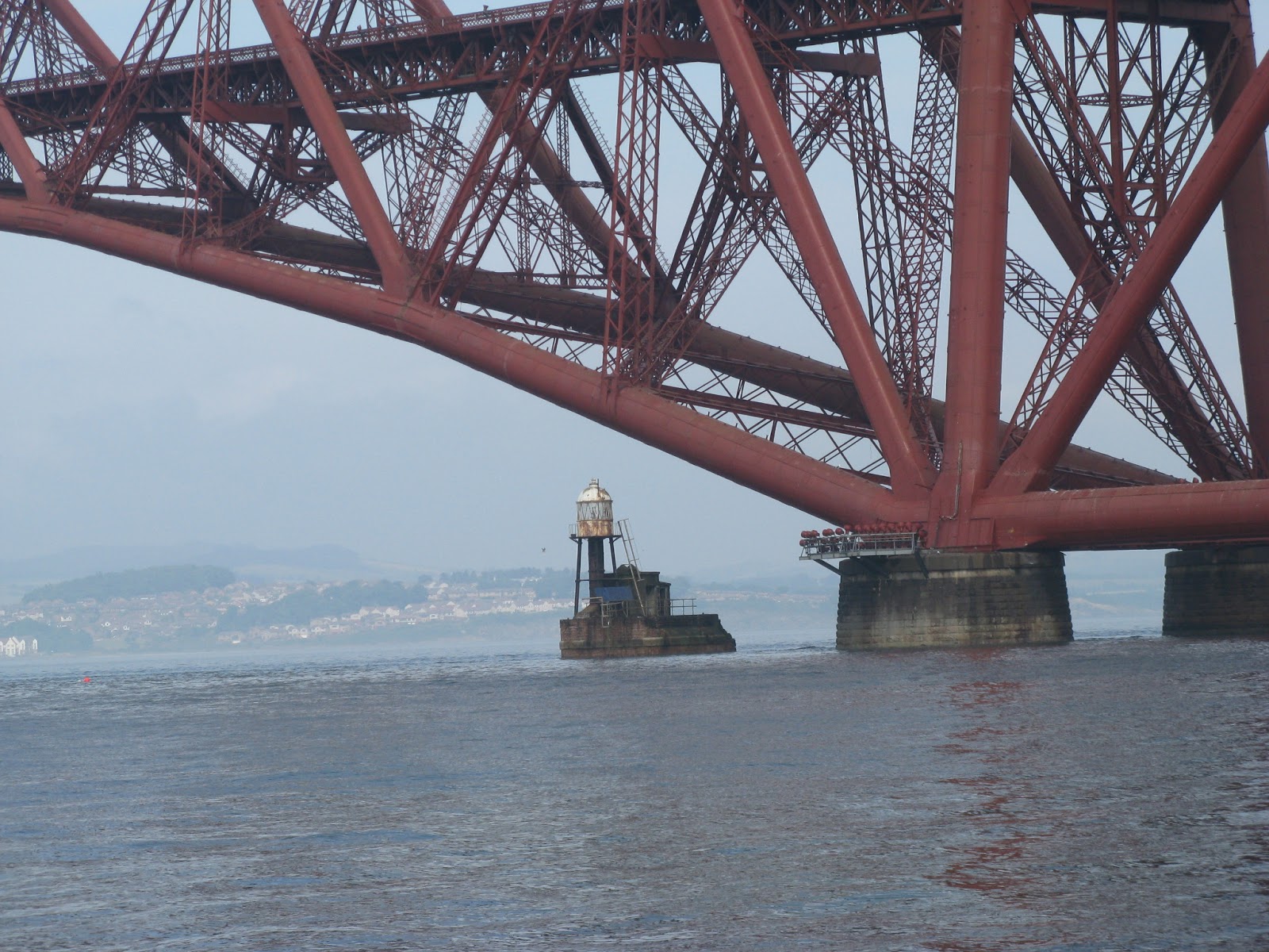
The rail bridge with quite a large gas carrier about to pass beneath.
Can you see the train, tiny isn't it or is it that the bridge is massive.
Truly awesome, especially considering when it was built.
A lot of the islands in the Forth are riddled with fortifications from the Hitler war as the naval dock yards are just upstream.
Inbound for the oil jetty.
Inchcolm and the abbey through the misty haze. The grand city of Edinburgh and the docks of Leith are on the opposite shore but I didn't see them at all.
The trip out to the Isle of May was a bit bumpy and I was starting to have second thoughts about the efficacy of her anchorage. 1. It was dark and I had to anchor about 60 metres from a cliff, in the right place as there are adjacent rocks. 2. I could see that the place was covered in pot markers. 3. The pilot book said it was 4 metres at low water, it was low water and I couldn't find anything less that 11.5 metres. That meant the sand had been scoured off the rocky ledge. 4. It's not brilliant holding anyway. Still I chucked 45 metres of chain overboard and spent a fretful night listening to it scrape and grumble over the rocky sea bed. The chart plotter said we did 1.9 miles in the night ranging about but we didn't move more that 60 metres in all so not bad really. Hear is the Isle of May in the morning just before she disappeared in the fog.